Ansichten Ausland
-
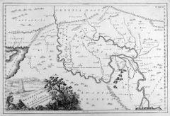 IRAK. - Karte. - Mesopotamia et Babylonia etc. Zeigt das historische Zweistromland um Euphrat und Tigris von der Mittelmeerküste Syriens bis zur Grenze zum Iran.
Kupferstich nach Chr. Cellarius bei J.B. Ghisi, Rom, 1774, 30 x 45 cm.
T. XXVII aus: "Cellarius' Geographica Antiqua in Compendium Redacta". - Titelkartusche mit Babylonischem Turm links unten. (Artikelnr. 30204EG)
Erfahren Sie mehr200,00 € Inkl. MwSt. -
PALÄSTINA. - Karte. - Arabia Petraea er Deserta. Historische Karte Palästinas, die Mittelmeerküste im Norden bis Antiochia, im Süden das nördliche Rote Meer, im Westen bis zum Persischen Golf .
Kupferstich nach Chr. Cellarius bei J.B. Ghisi, Rom, 1774, 30 x 45 cm.
T. XXVI aus: "Cellarius' Geographica Antiqua in Compendium Redacta". - Mit dem heutigen Gebiet von Jordanien und Kuweit. Titelkartusche mit antiken Ruinen rechts oben. (Artikelnr. 30206EG)
Erfahren Sie mehr220,00 € Inkl. MwSt. -
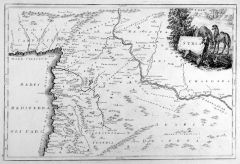 SYRIEN. - Karte. - Syria. Historische Gesamtkarte, die Mittelmeerküste bis Tyrus, im Osten der Euphrat.
Kupferstich nach Chr. Cellarius bei J.B. Ghisi, Rom, 1774, 30 x 45 cm.
T. XXIV aus: "Cellarius' Geographica Antiqua in Compendium Redacta". - Titelkartusche mit Kamelen rechts oben. (Artikelnr. 30205EG)
Erfahren Sie mehr200,00 € Inkl. MwSt.
